
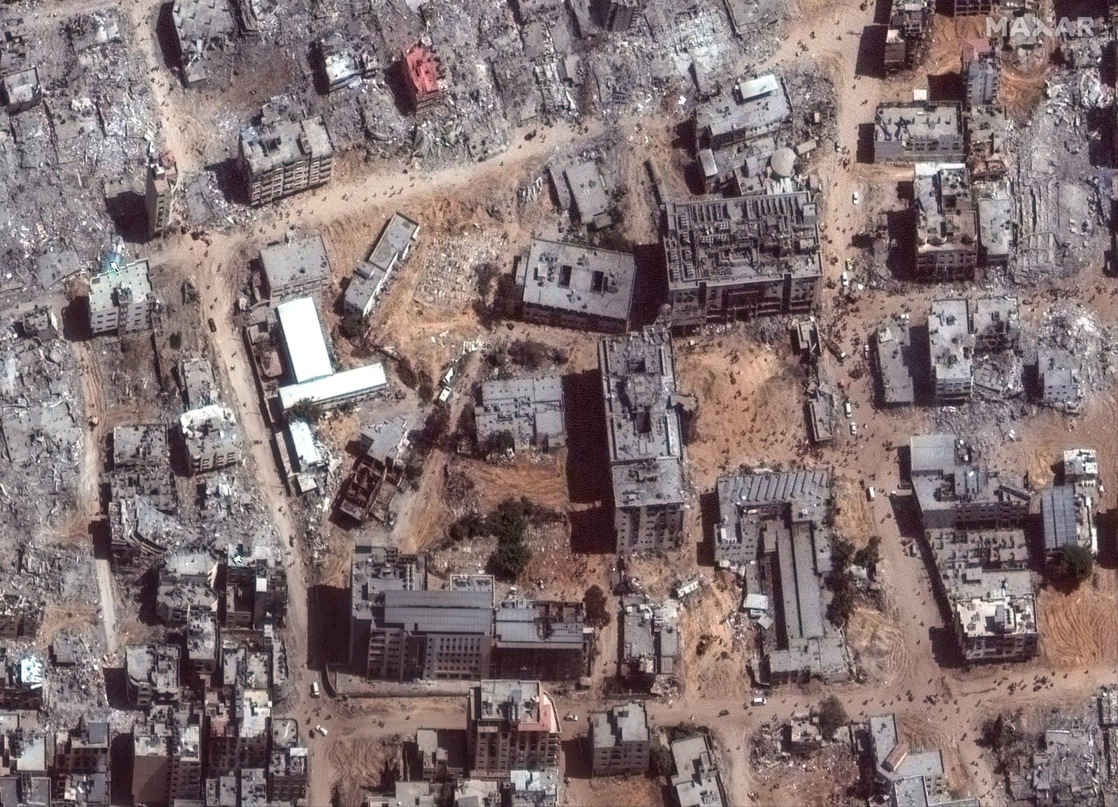
Gaza City Destruction: Satellite Images Show the Devastation Left by the Israel-Hamas War
New satellite imagery is giving people around the world a stark view of the destruction left across Gaza after nearly three years of war between Israel and Hamas. Updated Google Maps and other satellite images show neighborhoods that once contained homes, businesses, roads and farmland now heavily damaged or replaced by rubble.
The images have attracted renewed attention in the United States and internationally because they allow viewers to compare Gaza before and after the war from above. While the images cover different locations and were captured on different dates, they provide a powerful visual record of how dramatically the landscape has changed.
Satellite Images Show Gaza Before and After the War
Before the conflict began in October 2023, Gaza had densely populated residential neighborhoods, apartment buildings, schools, businesses, agricultural areas and major roads.
Recent satellite imagery shows a very different landscape in many areas. Buildings have disappeared from entire blocks, roads are difficult to recognize and large sections of land are covered with debris or appear cleared.
A recent analysis of updated Google Maps imagery found extensive damage across locations including Gaza City, Rafah and Khan Younis. The imagery does not come from one single date; different areas were photographed at different times between 2024 and 2026.
The United Nations Satellite Centre (UNOSAT) reported that, as of June 16, 2026, approximately 201,290 structures in Gaza had been damaged, representing about 82% of all structures in the territory. More than 134,000 structures were classified as destroyed.
Gaza City Neighborhoods Changed Beyond Recognition
Some of the most striking comparisons involve areas of Gaza City and surrounding communities.
Shijaiya, one of Gaza City’s historic neighborhoods, has suffered extensive destruction. Satellite views show large stretches where residential buildings once stood but are now heavily damaged or gone.
Other parts of northern Gaza, including Beit Hanoun, have also experienced enormous physical destruction. AP reporting based on satellite imagery found that entire towns and neighborhoods have been substantially flattened during the conflict.
The images also reveal that the damage is not limited to individual buildings. In many locations, the destruction affects entire urban blocks, infrastructure networks and agricultural areas.
Rafah Has Also Been Heavily Destroyed
The latest satellite analysis has placed particular attention on Rafah, a city in southern Gaza that once had a population of roughly a quarter-million people.
AP reporting published October 7 said satellite imagery shows Rafah has been extensively razed, with some areas showing widespread demolition and cleared land. The report said Israeli forces have continued demolitions in areas under their control even after the ceasefire agreement reached a year earlier.
The Israeli military has said its operations are connected to security concerns, including Hamas infrastructure and tunnels. Hamas has disputed Israeli claims about its activities and has accused Israel of undermining the ceasefire.
What the Satellite Images Cannot Show
Satellite photographs can show the physical destruction of Gaza, but they cannot fully capture the human consequences.
Millions of Palestinians have experienced displacement, loss of homes and disruption to basic services. Recent reporting has shown large tent communities appearing in areas where buildings and farmland previously existed.
The destruction has also created a major challenge for future Gaza reconstruction. Rebuilding homes, hospitals, schools, roads, water systems and electricity networks will require enormous resources and a stable political and security environment.
The amount of rubble is another major problem. Before reconstruction can begin in many heavily damaged neighborhoods, debris and unexploded weapons would have to be removed and damaged infrastructure assessed.
Why the New Gaza Satellite Images Matter
For people who cannot enter Gaza independently, satellite imagery provides an important way to understand the scale of the physical damage.
The latest Gaza satellite images do not tell the entire story of the Israel-Hamas war, but they make one part of it visible: the transformation of a densely populated urban landscape into areas of rubble, damaged buildings, cleared land and temporary shelters.
As discussions about a lasting ceasefire, humanitarian aid and Gaza reconstruction continue, these before-and-after images are likely to remain an important record of what happened to communities across the territory.
The satellite evidence also highlights why rebuilding Gaza will be a long and difficult process, particularly in neighborhoods where much of the original urban infrastructure has been destroyed.
More Information: usmedianewz