
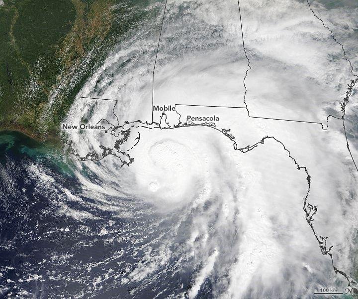
A tropical system developing in the Gulf of Mexico is drawing increasing attention from U.S. forecasters as it could strengthen into the first hurricane of the 2026 Atlantic hurricane season and reach the Gulf Coast this weekend.
As of Wednesday, October 7, the system is officially Tropical Depression Nine. The National Hurricane Center (NHC) said the depression had maximum sustained winds of about 35 mph and was expected to strengthen into a tropical storm and potentially a hurricane as it moves across the Gulf.
If the system becomes a tropical storm, it is expected to receive the name Isaias. Forecast models indicate that the storm could become a hurricane by Thursday before moving toward the northern Gulf Coast. However, the exact track and strength remain uncertain, meaning residents should continue monitoring official weather updates.
Where could the storm go?
The current forecast suggests Tropical Depression Nine will move generally eastward before turning north toward the U.S. Gulf Coast. The latest forecasts place the potential landfall zone somewhere from southeastern Louisiana across Mississippi and Alabama toward the Florida Panhandle.
The National Hurricane Center reported early Wednesday that the system was located roughly 345 miles west of Progreso, Mexico, and about 605 miles southwest of the mouth of the Mississippi River. It was moving east at about 5 mph.
Other forecasts also show a possible landfall during the weekend. Because tropical systems can change direction quickly, meteorologists are warning that the forecast cone should not be treated as a precise landfall line.
The Gulf Coast hurricane threat could therefore extend across several states, depending on how the system develops over the next few days.
Could it become a hurricane?
Forecasters believe strengthening is possible because the system is moving over very warm Gulf waters. The NHC currently expects Tropical Depression Nine to become a tropical storm and then potentially reach hurricane strength on Thursday.
Weather experts are also watching atmospheric conditions that could either help or limit development. Warm ocean water can provide additional energy to a tropical cyclone, while strong wind shear and dry air can weaken a developing storm.
That means the final hurricane intensity forecast is still subject to change.
Heavy rain and flooding could be a major concern
Even if the storm does not become a powerful hurricane, rainfall could become one of its biggest threats.
Current forecasts call for roughly 3 to 6 inches of rain across parts of the central Gulf Coast, with locally higher totals possible. Heavy rainfall could produce flash flooding, especially in low-lying areas and locations that receive repeated thunderstorms.
The storm could also produce storm surge, dangerous surf, strong winds and rip currents along portions of the Gulf Coast. Some inland areas of the Southeast could experience severe thunderstorms or isolated tornadoes as the system interacts with other weather features.
Which U.S. states could be affected?
The areas currently being watched most closely include:
- Louisiana
- Mississippi
- Alabama
- Florida Panhandle
- Parts of the broader Southeast
Texas is expected to remain outside the storm’s main projected path, although parts of the Texas coast could still experience rough surf, increased moisture or scattered rainfall.
Florida officials have already taken precautionary steps, with Gov. Ron DeSantis declaring a state of emergency for 25 counties ahead of potential impacts in the Panhandle and Big Bend region.

Why this storm is unusual
The possible hurricane is attracting additional attention because the 2026 Atlantic hurricane season has been unusually quiet so far. If the system becomes a hurricane, it would be the season’s first Atlantic hurricane. Some reports note that this could make it the latest first hurricane of an Atlantic season in more than a century.
The system is also important beyond weather concerns. The Gulf of Mexico contains major U.S. oil and natural-gas production facilities. Reuters reported Wednesday that the approaching storm was already affecting energy markets because of potential disruptions to offshore production and transportation.
What residents should do now
People along the Gulf Coast should not wait for a final landfall forecast before preparing. Residents in potentially affected areas should check local emergency alerts, review evacuation plans, secure outdoor items and keep basic supplies available.
Most importantly, residents should follow updates from the National Hurricane Center and local National Weather Service offices, because the storm’s track and intensity could change significantly over the next 48 to 72 hours.
At this stage, the biggest message from forecasters is simple: the Gulf Coast hurricane threat is real, but the exact location and strength of the storm are not yet certain.